About Kyrgyzstan
Contacts
UZBEKISTAN
45/405 Shota Rustaveli Street
100100
Tashkent, Uzbekistan
PAKISTAN
Mezzanine Floor., Office 8A
Mushtaq Mansion, Block D
Fazel-e-Haq Road, Blue Area
Islamabad, Pakistan
E-mail: tashkent@sitara.com islamabad@sitara.com
Phone (Uzbekistan): (99871) 2814148, (99871) 2814149, (99871) 2553504
Phone (Pakistan): (9251) 2805583, (9251) 2805288
Fax: (99871) 1206500
Social links:


Send request
-
 read more
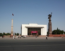 BishkekBishkek, the capital of Kyrgyzstan, is situated at an altitude of 750 meters above sea level. It has area of 124 square km and a population of approximately 670,000 people. The city was constructed on the site of a fort (called Pishpek) built by the Khan of Kokand in 1825 and destroyed by the Russians in 1862. Russians and Ukrainians began to settle here in the latter decades of the 19th century, ... read more
 -
read more
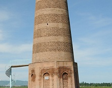 Burana TowerThe Burana archeological and architectural complex is situated 12 km to the south of Tokmak. The name Burana is believed to be a corruption in a local dialect of the Turkic word munara "minaret": for centuries, all that remained of Balasagun were the topless, 25-meter minaret and the overgrown mound of the old citadel. Originally, minaret was 37 to 38 meters high, but in the 16th century an earthq... read more
 -
read more
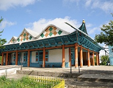 KarakolKarakol is situated at an altitude of 1700 meters near the eastern end of Lake Issyk-Kul and near the highest mountains - Peak Pobedy (7439 m) and Khan-Tengry (7010 m). It is the principal town in the region with population of 70,000 people, and the best base from which to explore the lakeshore. It's a low-rise town, famous for its apple orchards and Sunday market (one of the best in Central Asia)... read more
 -
read more
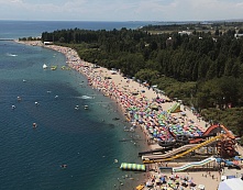 Issyk-Kul LakeIssyk-Kul means "hot lake" in Kyrgyz and confirms its name by not freezing in winter. It sits 1609m above the sea level and has an area of 6206 square km (179 km long and 60 km wide), making it the second largest alpine lake in the world after Lake Titicaca in South America. About 134 rivers flow into the lake. No river flow out of Issyk-Kul so the lake accumulates all mineral substances carried h... read more
 -
read more
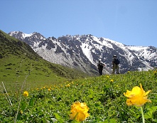 Ala-Archa CanyonThe Ala-Archa canyon is located in the highest, central part of the Kyrgyz Ridge which is famous for its eternal snow-stretching for almost 200 km - and such peaks as Dvurogaya (4,380 m), Korona (4,860 m), Baylyanbaish (4,700 m), and the highest peak of the Kyrgyz ridge - Semenov-Tian-Shansky (4,875 m). The Ala-Archa canyon is the center of the Ala-Archa National Park, one of the main tourist attr... read more
 -
read more
Ak-BeshimLocated in Tokmak and neighbouring the Burana Tower, Ak-Beshim are the ruins of the ancient town. The mounds and ridges at Ak-Beshim delineate a large town (35 hectares) which has yielded remains of a Nestorian church and a Buddhist temple from the 7th and 8th centuries. Ak-Beshim is reckoned to have been the most important town in its time. The site has since been reliably identified as Suyab. Me... read more
-
read more
Cholpon-AtaCholpon-Ata is located at an altitude of 1609 meters above the sea level at the northern side of the Issyk-Kul Lake (250 km from Bishkek). In the area there are the significant mountain gorges of Kungei, Ala-Too, Chon-Koi-Suu and Cholpon-Ata. It's worth visiting a number of waterfalls, lakes, and forests. The great panoramic view of the Terskei Ala-Too rise up from the emerald riverbanks to the hi... read more
-
read more
 Krasnaya RechkaThe sight is located only 30 km east of Bishkek in the village "Krasnaya Rechka". The irregular mounds and softy eroded clay walls rippling off the valley floor are the remains of the Silk Road City of Navekat, which flourished from the 6th to the 12th centuries. The founders were Sogdians; Navekat means "new city" in Sogdian. Archaeologists have discovered remains of a Buddhist temple, a fort... read more
 -
read more
OshThe Osh region is the largest region of Kyrgyzstan, with a multiethnic population consisting of 1.4 million people. It lies in the southern part of Pamir-Alai and includes the hilly lowlands of the Ferghana Valley. The geography of the region is one of contrasts. At one edge of the Ferghana Valley gentle hills rise into mid-sized mountains and then gradually into high altitude ranges. The cli... read more
-
read more
Tash-RabatThe stone fortress Tash-Rabat is located at the altitude of 3530 m, 80 km far from Torugart (China-Kyrgyz border post) and 90 km from Naryn town. Recent investigations have shown that this monument dates back to the 10th century. It is supposed to be the monastery of Nestorian-Christians (or Buddhist) who came here before the Mongolian invasion and before the spreading of Islam in Tian Shan. T... read more
-
read more
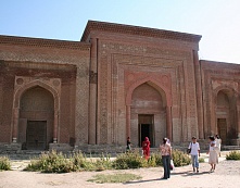 UzgenUzgen town, which is situated on the right bank of the mountain river Kara-Darya (60 km away from Osh), was founded in the 8-9th centuries. The fourth city according to its size after Axiket, Kuba and Osh it was a large trade centre on the outskirts of the state of Samanids. From the second part of the 11th century till the beginning of the 13th century this mighty fortress, Uzgen, was the capital... read more